Air New Zealand Flight 901 - Part 2
Antarctica - Mount Erebus 28 November 1979 - Accident Report
Part 1 of this Viewpoint set the scene for looking more closely at the Antarctic “Mount Erebus” crash of Air New Zealand Flight 901 (TE 901) Registration ZK-NZP) on 28 November 1979.
This Part notes key points in the Air Accident Inspector’s report. As ever, a full reading of the report is advised - Accident Inspector’s full report - Web.pdf (erebus.co.nz).
Basic information
Paragraphs 1.1 to 1.6 are factual statement and are mostly undisputed - History of the Flight (para 1.1), Injuries to persons (1.2), damage to the aircraft (1.3), Other damage (1.4), Personnel information (1.5), Aircraft information (1.6).
The accident occurred, during daylight, at 0049:50 hrs GMT.1 The flight was toward a uniform snow-covered ice slope beneath 8/8 cloud cover. The collision point was at elevation 1467 ft amsl. The report (para 1.1.1) states the elevation of the summit of Erebus to be 12450 ft.2
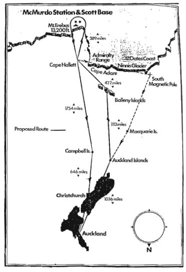
The route was from Auckland via South Island (NZ), the Auckland Islands, Balleny Islands3, Cape Hallett, to McMurdo with a return via from McMurdo, via Cape Hallett, then Campbell Island to Christchurch. Map 1 shows the intended route - (south at the top).
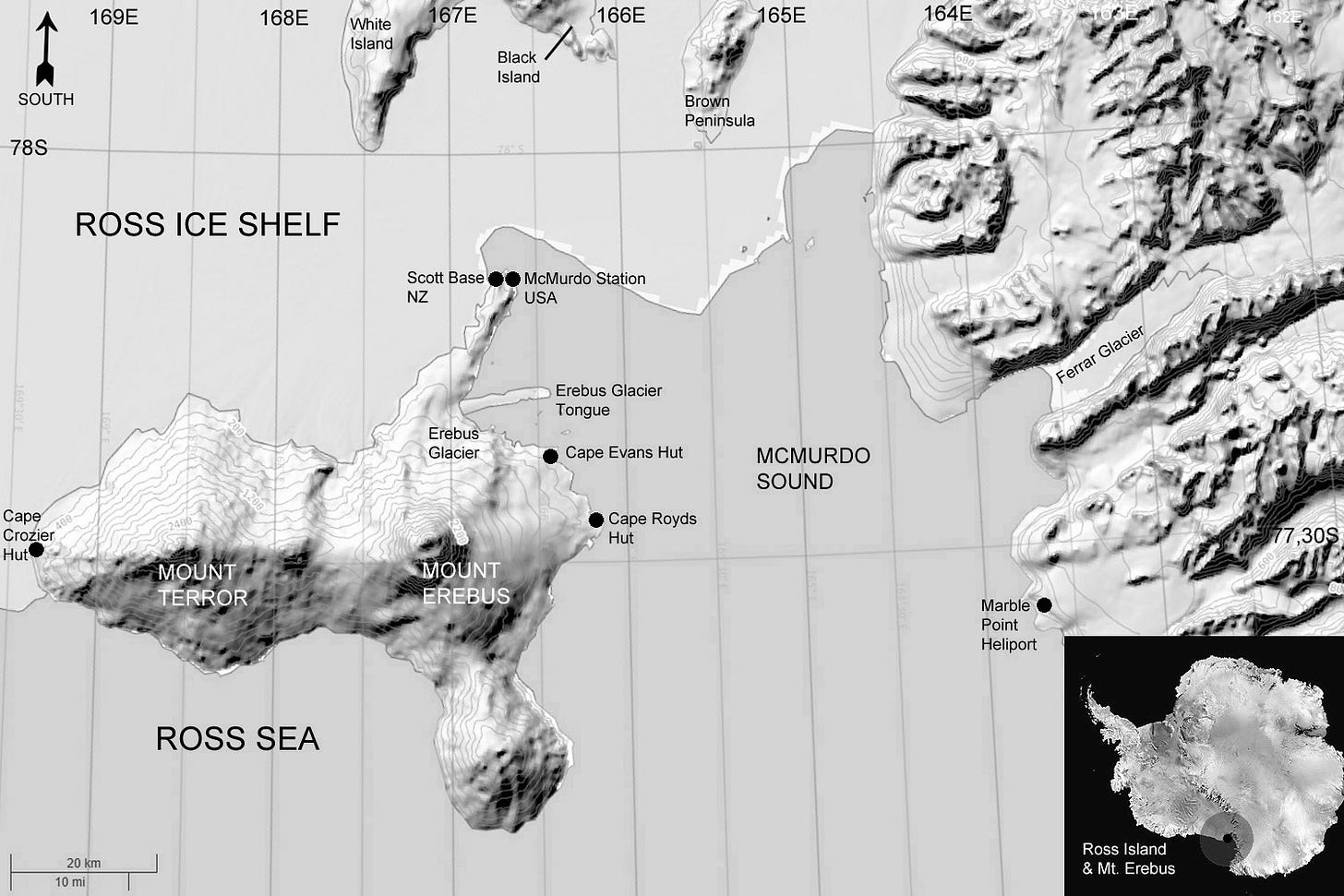
Map 2 shows Mount Erebus, on Ross Island, approximately 25 miles to the north of McMurdo Station / Scott Base - (south is at the top of the map). The Bay to the north of Erebus and Terror is Lewis Bay - (i.e. roughly where the words ROSS SEA appear in Map 2).
Radio and Navaids
Para 1.1.5 refers to problems experienced with radio and navaids
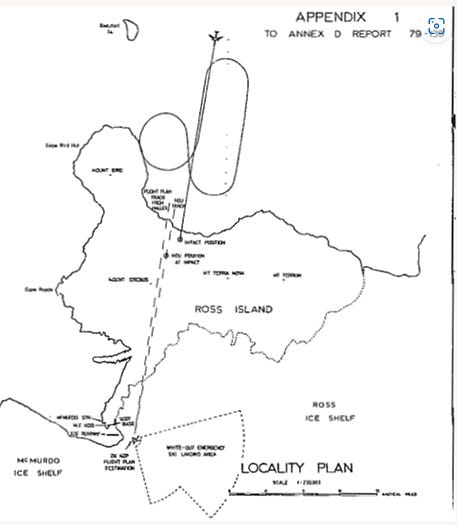
1.1.6 describes the descent -
This is shown in a diagram in the report (north at the top) -
Meteorological Information
At 0018 GMT there was contact with McMurdo to obtain weather information -
The Wright and Taylor Valleys are on the opposite (i.e. west) side of McMurdo and well away from Ross Island and Erebus.4 However, the pilot declined the “better prospect” of the dry valley area. On TE901 the commentator was the explorer Mr Peter Mulgrew.5
The McMurdo weather at 0010 hrs was -
The atmospheric pressure reported was “Altimeter 2930” which is 29.30 inches of mercury. (International Standard Atmosphere sea level pressure is 29.92).
The term “surface fair” meant snow surface features can be identified by contrast. No definite shadows exist. (The sun is usually totally obscured). “Horizon fair” meant - The horizon may be identified although the contrast between sky and snow is not sharply defined.6
Other weather information became available to the investigation but much of it relates to times after the time of the accident (00.50 hrs). Notably, at 0105, a helicopter operating at Ross Island reported poor surface definition.
The report continues with further factual information.7 Again, let us note key points.
Navigation (1.8)
Ground-based navigational aids were approved for “Antarctic Support Deep Freeze” aircraft but others could use them at “their own risk.” The US Navy was responsible for maintenance of the aids. Every approach chart, letdown procedure and radar navigation chart contained certain warnings -
All the navaids were reportedly operating normally but the McMurdo Non-directional beacon (NDB) had been withdrawn from service but was left transmitting.
TE901’s Distance Measuring Equipment (DME) was unable to successfully “lock on” to the McMurdo TACAN and so could not obtain a distance from the TACAN.
The McMurdo surveillance radar had a range in the region of 40 nm but, according to the report, it did not detect the aircraft. The report note that the radar installation was an AN/FPN 36 QUAD system but gives no fuller details.8
The ability of a primary radar to detect targets depends on many factors including aerial design, transmitted power, target size, how the target reflects the radar signal, distance of the target from the radar, height of the target, and whether there is high ground between the radar and the target.
McMurdo was also equipped with IFF (Identification Friend or Foe - an early version of secondary radar). The aircraft’s transponder was found to be on standby when it was recovered from the wreckage.
The aircraft was navigated primarily by Inertial Navigation.9 It also carried a Bendix RDR 1F weather radar but this not a navigation aid. The report states (para 1.8.9) that it had weather and mapping modes and that, according to the manufacturers, the high ground on Ross Island ought to have been shown on the radar.
As noted earlier, TE901 was only able to make occasional contact on two VHF radio channels. VHF radio is “line of sight” and so high terrain could result in non-contact. VHF is relatively short range. HF radio remained reliable and was not line of sight. HF can be used over long distances.
Cockpit Voice Recorder (1.11)
The Cockpit Voice Recorder (CVR) was recovered. Preparation of a transcript was made more difficult because of extra persons being on the flight deck including some passengers. Annex C of the report gives further details but it was not possible to identify certain voices.
At time 0047:43 the captain said - We might have to pop down to fifteen hundred here I think - to which the co-pilot replied - Probably see further in anyway.
Between 0047:55 and 0047:59 the transcript reports an unidentified voice saying - Bit thick here eh Bert? Then, at 0048:05, Flight Engineer Moloney reportedly said - You’re really a long while on ……. instruments this time are you [The dots indicate a pause]. Moloney was in the flight deck but not at the engineer’s panel.
At 0048:30 the captain said -We didn’t get that Tacan frequency did we? The co-pilot replied No. There was a little more discussion about that and then, at 0048:46 the captain said - Actually those conditions don’t look very good at all - do they? The commentator (Mulgrew) replied - No they don’t.
At 0049:10 there was an unsuccessful attempt to contact Mac Tower on frequency 134.1. A voice then said (0049:24) - I don’t like this. At 0049:30 the captain said - We’re twenty six miles north we’ll have to climb out of this. At 0049:33 the co-pilot said - It’s clear on the right and (well) ahead. [The brackets indicate questionable text]. The captain replied - Is it? - and the co-pilot said Yes.
There was then some discussion about how to climb out with the co-pilot saying - No high ground if you do a one eighty
The Ground Proximity Warning System (GPWS) gave an alarm at 0049:44. The captain asked for G round power please. The recording ended at 0049:50. By the time GPWS activated, the “experienced pilots” would not have avoided the collision - (para 1.16.4).
Digital Flight Data Recording (DFDR) (para 1.11)
This was recovered intact and recorded the two orbit descent and also the fact that the aircraft flew straight and level with a 5 degree nose up attitude at 260 kts (Indicated Airspeed) - (para 1.11.4 and Annex D).10
Additional information (1.17)
Two of the three pilots had received a specially devised audio-visual, written and simulator route qualification briefing but the report notes a number of items that were not included such as the procedure for determining the minimum flight level recognised for the Antarctic area and specifically for the McMurdo control area. There was no comprehensive discussion in the briefing of the visual phenomenon of whiteout. (Details of Whiteout are in the report at 1.17.46 to 1.17.58).
Topographical maps were not issued until the day of the flight and were of relatively small scale - 1:500,000,000 or 1:300,000,000.
The briefing used a plan showing the destination point for McMurdo to be TWO degrees TEN minutes of longitude to the west of the McMurdo waypoint actually supplied to the crew for the flight - (para 1.17.7). At the latitude of McMurdo, that is a distance over the ground of around 27 nm.
Descent procedures
Air New Zealand had a written procedure setting out “minimum sector altitudes” for the descent. Essentially, this required 16,000 ft approaching McMurdo but, in a defined sector to the south of Erebus, descent could be to 6,000 ft provided that visibility was 20 km or better, no snow showers, and descent coordinated with McMurdo ATC. The company’s minimum sector altitudes had not been communicated to McMurdo ATC. (See 1.17.13).
At para 1.17.19 it is recorded that there was no requirement for pilots to have undertaken a flight to Antarctica under supervision.
Analysis - Section 2
Accident Inspector’s full report - Web.pdf (erebus.co.nz).
The analysis begins (2.1) - “The initiating factor in this accident was the captain’s decision to make a VMC descent below the specified minimum safety height while north of McMurdo.”
The Inspector noted the absence of some “significant information” in the route qualification briefing for which Air New Zealand was responsible - (2.2).
The three “maps” used at the briefing all showed a track located clear of the high ground and passing west of the mountains. One of the maps issued on the day of the flight also showed this more westerly track. The actual route passed to “the east over very high ground instead of over the sea level ice shelf as portrayed on the briefing “maps” - (2.4).
The airline had altered the coordinates for McMurdo to a more easterly position but maps continued to show the more westerly position. The crew was not informed of this change.
Paragraph 2.5 was therefore particularly surprising - “In the case of this crew no evidence was found to suggest that they had been misled by this error in the flight plan shown to them at the briefing” - (2.5).
The Inspector, in discussion with other Air NZ crews, found certain “misconceptions” including the minimum altitude to which the aircraft was permitted to descend in visual conditions (VMC) and the actual topography below the flight planned track from Cape Hallett to McMurdo - (2.7).
The pilots received no explanation of the horizon and surface definition terms used in weather reports - (2.10).
Para 2.11 describes how the captain took advantage of a hole in the cloud cover to descend but the paragraph criticises the captain for what the Inspector perceived to be a breach of safety requirements -
The descent was by two orbits - first right and then left (para 2.14). After the second orbit, TE901 resumed the southerly track programmed into its inertial navigation system. On that track it descended to 2000ft and then Captain Collins decided to go down a further 500ft to obtain a better view below the continuous cloud layer - (para 2.14).
Para 2.16 described the concern expressed by the captain - “ …. the captain headed the aircraft toward the cloud covered island and no expression of doubt was made by the first officer. The captain descended the aircraft a further 500 feet from the original 2000 feet but at 1500 feet and at a distance to run of 26 miles he finally became concerned and stated “We’re 26 miles north, we’ll have to climb out of this.”
The Inspector commented at para 2.17 - weather conditions had high potential for a “whiteout.”
There was some discussion between the captain and first officer about the most suitable climb out path. Ground proximity warning then activated and the crew responded without undue hesitation but the warning was 6.5 seconds before impact - too late for the crew’s action to have any significant effect - (2.18).
The ground proximity warning was delayed because the terrain closure started from above a 300 foot coastal cliff instead of a steadily increasing slope which would have triggered the warning approximately 3 seconds earlier.
2.20 then re-iterates that the captain did not comply with the company’s requirements to limit the descent to 16000 ft until overhead “McMurdo Field.”
Conclusions - Section 3
There are 36 conclusions. They do not all need to be set out here but they included -
The crew were not monitoring their actual position in relation to the topography adequately - (3.15)
The captain initiated a descent to an altitude below the IMC (16,000 feet) and VMC (6,000 feet) minima for the area in a cloud free area but in contravention of the operator’s briefing and outside the sector approved for the descent to 6,000 feet - (3.18).
and then - at para 3.37 ….
Recommendations - Section 5
17 recommendations were made by the Inspector. These included no descent below minimum sector altitude to be authorised in the Ross Island area unless the aircraft is under continuous radar surveillance - (5.10).
My note
The Inspector’s finding of the “probable cause” was controversial. It was inevitable that the media would concentrate on the “probable cause” statement and, at best, they mostly gave much less attention to the 36 more detailed conclusions and the 17 recommendations.
The NZ Attorney-General, James McLay11, announced that there would be a Royal Commission of Inquiry and, on 21 April 1980, High Court of New Zealand Judge Peter Mahon was appointed as Commissioner by the Governor-General.12 Hearings were set to begin in July. Despite objections from a number of parties, the government released the Inspector’s report at midnight on 19 June.
For me at least, the report generally lacked depth of analysis in a number of areas including -
the search and recovery operation and the handling of items found in the wreckage
the possible impact on the mindset of the crew of a briefing that used maps showing a track inbound to McMurdo to the west of the track which was actually inserted into the inertial navigation system on the morning of the flight
the United States McMurdo ATC operation and its equipment - the McMurdo radar either did not detect TE901 or the ATC operators did not see it.
An aircraft flown by careful and experienced pilots had flown into the side of a mountain. The pilots were held in high regard by colleagues and certainly not known for risk-taking. The Inspector’s report was criticised and calls for a public inquiry were unsurprising. More was to be revealed by the Royal Commission - the subject of Part 3 ……
Difference between GMT and Local time in Antarctica is either 12 or 13 hours dependent on date. McMurdo Station: (time.is)
Yet the map in the Report at Annex H shows 13,200 ft. (In Part 1 of this Viewpoint I linked to a website stating 13,350 ft). Nothing particularly turns on the various figures though it is interesting that, even in 2023, online research produces varying figures.
The report para 1.1.2 states Baleny Island. The route map (Report - Annex H) states Balleny Islands.
The Wright and Taylor valleys are described at What Are the Dry Valleys of Antarctica? - WorldAtlas.
The “commentator” was someone, with knowledge of Antarctica, able to point out features to passengers and provide them with information. Sir Edmund Hillary had sometimes acted as commentator. Peter Mulgrew (killed at Erebus) was Hillary’s friend and both were participants in the 1958 transantarctic expedition. In 1975, Hillary’s first wife (Louise) and daughter (Belinda) were killed in an air accident in Nepal. Hillary married Peter Mulgrew’s widow “June” in 1989. The end of the 'big mountain days' - Edmund Hillary | NZHistory, New Zealand history online
See report Annex B
Aids to navigation (1.8), Communications (1.9), Aerodrome information (1.10), Flight recorders (1.11), Wreckage and impact information (1.12), Medical and pathological information (1.13), Fire (1.14), Survival aspects (1.15), Tests and research (1.16), Additional information (1.17) and New investigation techniques (1.18).
The installation was a mobile type of radar installation, with limited coverage, used by the military.
What is an Inertial Navigation System? · VectorNav. “Waypoints” were entered (as Latitude and Longitude coordinates). After being switched on, INS required a period of alignment when the aircraft had to be stationary. That was usually achieved on the airport parking stand. The DC10-30 carried a triple-platform Area Inertial Navigation System (AINS) which produced, as numerous flights had shown, a high degree of accuracy.
Flaps etc were not deployed so as to avoid any retraction problems which would make the return to New Zealand difficult. Report 2.19
Sir James Kenneth McLay (born 1945) - White Silence: Former Deputy PM's biggest regret after Air NZ Erebus crash | Stuff.co.nz
The Governor-General represents the Monarch


